Kenai National Wildlife Refuge
Fishing Destination
| Kenai National Wildlife Refuge | |
|---|---|
IUCN category IV (habitat/species management area)
| |
 Glacier and Glacial Lake, Kenai National Wildlife Refuge | |
 | |
| Location | Kenai Peninsula Borough, Alaska, USA |
| Coordinates | 60°20′N 150°30′W / 60.333°N 150.5°WCoordinates: 60°20′N 150°30′W / 60.333°N 150.5°W[1] |
| Area | 1.92 million acre (7,770 km²) |
| Established | 1980 |
| Governing body | U.S. Fish and Wildlife Service |
| Official website | |
The Kenai National Wildlife Refuge is a 1.92 million acre (7,770 km²) wildlife preserve located on the Kenai Peninsula of Alaska. The refuge was created in 1941 as the Kenai Moose Range, but in 1980 it was changed to its present status by the Alaska National Interest Lands Conservation Act. There is a wide variety of terrain in the refuge, including muskeg and other wetlands, alpine areas, and taiga forest. The refuge protects several large mammals, including brown bears, black bears, dall sheep, moose, and caribou, as well as thousands of migratory and native birds. There are numerous lakes, as well as the Kenai River, and the refuge is a popular destination for fishing for salmon and trout. The refuge has several campgrounds and boat launches, including two developed campgrounds, one at Hidden Lake and another at Skilak Lake, both accessible from Skilak Lake Loop Road, which intersects the Sterling Highway at both ends.[2] The refuge is administered from offices in Soldotna.
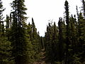 A taiga forest section of the Seven Lakes trail
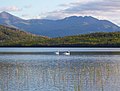 Trumpeter Swans on Lower Ohmer Lake
 Dolly Varden and Rainbow Trout fry in one of the refuge's many lakes
 Lowland lakes


References
- ^ "Kenai National Wildlife Refuge". Geographic Names Information System, U.S. Geological Survey. http://geonames.usgs.gov/pls/gnispublic/f?p=gnispq:3:::NO::P3_FID:1416059.
- ^ The Milepost 59th edition, pg 588 ISBN 978189215421
- Article Source: http://en.wikipedia.org/
More Stories: http://blackboxfishtalk.blogspot.com/
No comments:
Post a Comment